H-1117 Budapest, Pázmány sétány 1/C., Hungary. E-mail: krub@freemail.hu)
Please refer to this work as:
Database of lunar-like rilles on Mercury, Kereszturi A., 2002., LPSC XXXIII. 1663.
Introduction: In our previuos work we searched fo lunar-like rilles on Mercury [1] and found about 60-90 possible sinuous rilles on the images of the first encounter of the Mariner-10. This abstract is about an increasing database on the found rilles on Mercury. The sinuous lunar rilles (rimae or channels) were carved by thermal erosion of lava flows and/or subsequent collapse of lava tubes on the mare basalt terrains of the Moon [2,3]. Because of the several similarity between the evolution of the Moon and Mercury there is reason to analyse channels on Mercury too [4].
Working method: In the first phase of the database making processed images [5] were surveyed with visual method looking for possible sinuous rilles (channels). The images were made by the Mariner-10 during its first encounter with 0,2-2 km resolution. The visual searching is somewhat subjective but up to date no better method is known. (In the future we are planning to use some kind of shadow based image processing with different filter orientations to search for possible connection between the tectonic pattern and the orientation of rilles.) After the survey of the images any possible sinuous rill was analysed only on the best images among the several ones were made of the same area during the flyby. Because of the slow rotation of Mercury no changes were visible during the flyby on the images of the small sinuous rilles.
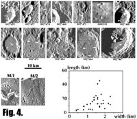
The best images were stretched to mercator projected map of Mercury with Idrisi software. Based on the so borned images we used Surfer software to determine the coordinates of certain surface points and after with simple trigonometric measurement we determined the physical dimensions in km. Because of the procedure we have high uncertanity in our results. The physical dimensions have uncertainty about 1-2 km. It is relative high to the sinuous rilles' dimension but can be used for statistical purpose. So this work is only a rough approach to search for the possible phenomena, characteristics and problems which will be useful for a detailed analysis in the future. We determined: 1. coordinates, 2. length, 3. average width, 4. the best image's reference number, 5. some important characteristics (crater chain-like apperarance, etc.)
We classified one structure as a possible channel if it satisfies the following criterions: 1. both of the Sun illuminated and shadowed side is visible. 2. based on the lighting condition it is a negative relief structure. 3. it does not has exact straight alignment. 4. it does not cut across terrains with highly undulating relief. (One can expect lava flows only to lower terrains and not upstream. Of course it is difficult to estimate the exact surface topography on the images.), 5. it does not align with obvious tectonic structures (estimated by the surrounding tectonic pattern.), 6. the structure does not appear to be connected craters (it was difficult to determine in several cases).
 General tendencies: There were many problematic cases in the identification,
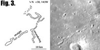
mostly with crater chains [6], chain like structures, connected depressions;
possible tectonic originated nearly straight fault-like structures and low relief
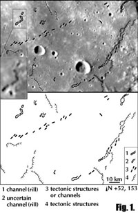
fold-like structures which are very frequent too (Fig. 1. is for the difficulties
of the identification, there are channels namely sinuous rilles), uncertain
channels and tectonic structures too.). The Caloris-basin has many rill-like
structures. They are not included here, and will be part of a different future
work. 56% of the already analised rilles started from somewhat crater-like
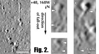
depressions. There are great number of channel-like structures on the ejecta
blanket of greater craters too, mostly originated from small craters or
depressions. In this case the flow direction is nearly parallel with the
direction of the ejecta fall-out.


